AGC HomeBiocomplexityArctic Geobotanical AtlasCAVMPublicationsEducation
Data HomeCircumpolarAlaskaOther

Alaska Maps and Data

uk25k Region map side 1
uk25k Region map side 2

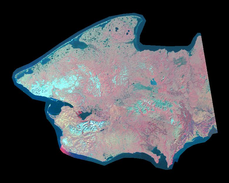
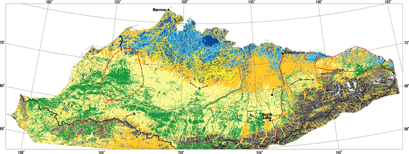
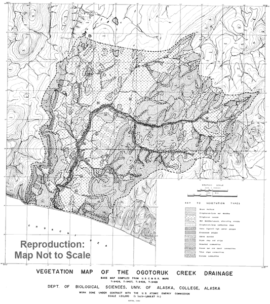
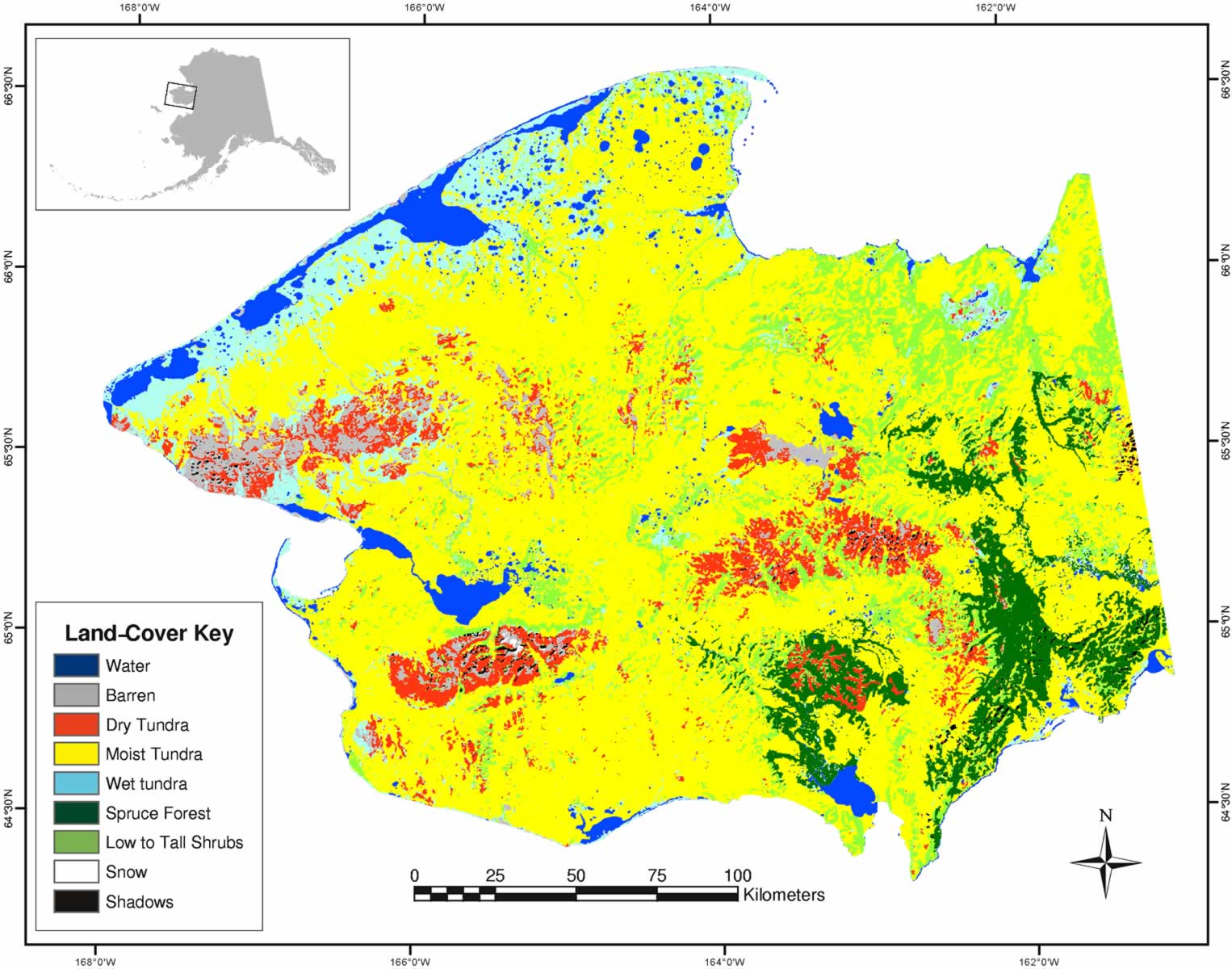
Vegetation in the vicinity of the Toolik Field Station, Alaska. 2008.
D.A. Walker and H.A. Maier. Biological Papers of the University of Alaska, No. 28. Institute of Arctic Biology, Fairbanks, AK. ISBN: 978-0-9767525-2-3.

High resolution (300 dpi) map:

Low resolution (50 dpi) map:

uk25k vegetation

Upper Kuparuk River Region Vegetation .

Seward Peninsula, False Color Infrared Image
779x625

False Color Infrared Image of the Seward Peninsula.


Seward Peninsula, MSS-derived land-cover
600x800 | 1200x1600

A preliminary Landsat MSS-derived land-cover map of the Seward Peninsula, Alaska: classification methods and comparison with existing data sets.

The data report is available as low (203 k) and high (1,206 k) resolution PDF files.

The unsupervised landcover classification is available as a GZip compressed grid saved as an ArcInfo export file.

Arctic slope boundary, polygon

Arctic slope boundary. Arc/Info polygon coverage.

Northern Alaska, MSS-derived land-cover
600x800 | 1200x1600

Landsat MSS-derived land-cover map of northern Alaska: extrapolation methods and a comparison with photo-interpreted and AVHRR-derived maps. Int. J. Remote Sensing. 20(15 & 16):2921-2946. [1.5 mb pdf]

150x200 max thumbnail
600x800 | 1200x1600

Landcover of the Kuparuk region.

Detailed description of the dataset (146 kb PDF).

The data is available as a GZip compressed Geo-TIFF file .

Vegetation Map of the Ogotoruk Creek Drainage
600x800

Johnson AW, Viereck LA, Johnson RE, Melchior H. 1960. Vegetation Map of the Ogotoruk Creek Drainage. Department of Biological Sciences, University of Alaska, College, AK. Unpublished. (Digitized: June 2004, Alaska Geobotany Center).

This map is similar to the vegetation map (Plate 5) described in:
Johnson AW, Viereck LA, Johnson RE, Melchior H. 1966. Vegetation and flora. In: Wilimovsky NJ, editor. The environment of the Cape Thompson region, Alaska. OakRidge, TN: U.S. Atomic Energy Commission. p 277-354
.

Copyright © 2000-2004 Alaska Geobotany Center. Materials contained on this web site are copyright protected under the provisions of a Creative Commons Attribution-NonCommercial-ShareAlike License. Materials may be freely downloaded, reprinted and redistributed for non-commercial use. Reproduction and redistribution of the materials on this web site, including derivative works, shall give credit to the Alaska Geobotany Center and remain subject to the above license. Any web pages that use this material shall contain a link pointing to the Alaska Geobotany Center home page (http://www.geobotany.uaf.edu/).


Last Updated: 10-Dec-2008
Please address comments to the Alaska Geobotany Center Webmaster