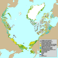
Physiognomic Units
- View Metadata (html or XML)
- View browse image [600x600] [1300x1300]
- Download compressed export file: veg_031210.e00.gz (3,360 kb)
| CAVM Home • Download Map • Download Data • Authors and Institutions • Publications |
Physiognomic Units
|
|
A detailed description of the vegetation units can be obtained from the most recent draft of the CAVM map. Modified final dataset for export as an ArcInfo polygon coverage. Last updated 2003-Dec-10
Polygons
Arc/Info 8.3 polygon coverage saved as a compressed (gzip) export (e00) file.
Projection LAMBERT_AZIMUTHAL
Datum NONE
Zunits NO
Units METERS
Xshift 0.0000000000
Yshift 0.0000000000
Parameters 6370997.0000000000 0.0000000000
6370997.00000 /* radius of the sphere of reference
-180 0 0.000 /* longitude of center of projection
90 0 0.000 /* latitude of center of projection
0.00000 /* false easting (meters)
0.00000 /* false northing (meters)
Description Cryptogam, herb barren Rush/grass, forb, cryptogam tundra Cryptogam barren complex (bedrock) Prostrate dwarf-shrub, herb tundra Graminoid, prostrate dwarf-shrub, forb tundra Prostrate/Hemiprostrate dwarf-shrub tundra Nontussock sedge, dwarf-shrub, moss tundra Tussock-sedge, dwarf-shrub, moss tundra Erect dwarf-shrub tundra Low-shrub tundra Sedge/grass, moss wetland Sedge, moss, dwarf-shrub wetland Sedge, moss, low-shrub wetland Noncarbonate mountain complex Carbonate mountain complex Nunatak complex Glaciers Water Lagoon Non-Arctic areas