Circumpolar Arctic Vegetation Map
AVHRR False-color Infrared Base Map
Download Data
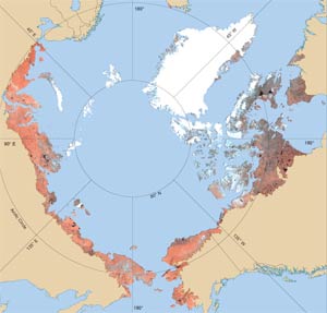
CAVM AVHRR False-Color Infrared Base Map
A false color-infrared (CIR) image, of Advanced Very High Resolution Radiometer (AVHRR) data, was used as a base map for drawing map polygons on a 1:4 million scale Lambert's azimuthal equal area projection. The image is composed of 1 x 1 km picture elements (pixels). The color of each pixel was determined by its reflectance at the time of maximum greenness, selected from biweekly images from 1 April to 31 October in 1993 and 1995. These periods cover the vegetation green-up-to-senescence period during two relatively warm years when summer-snow cover was at a minimum in the Arctic. The resulting image shows the Arctic with minimum snow and cloud cover. Red areas represent greater amounts of green vegetation; blue and gray areas represent sparse vegetation; black areas represent fresh water, and white areas represent ice. Most boundaries on the vegetation map correspond to features that can be seen on the image when it is enlarged to 1:4 million scale.
Data were obtained from the USGS Alaska Geographic Science Office. Glaciers and oceans were masked out using information from the Digital Chart of the World (ESRI 2000).